Hi all,
Being a new user to Radiance, I have very limited knowledge about it. I
might be completely wrong on what I am saying. If so, please correct me and
give suggestions.
My aim here is to render some before and after images for analysis of
daylight. I want to show existing and proposed conditions (annual)
irradiation maps using "radmap" tool.
The weather file that I am using is TMY2 .epw I used following to render
existing and proposed irradiation maps with "radmap" command:
radmap -s 8 -a 40.8 -o 73.9 -m 57 -n 1 -w WeatherTMT2.epw --no-albedo
--viewfile viewfile --radfile test.rad -x 2048 -y 2048
--keep-temporary-maps --sky-resolution 1024 --max-kWh 500 --max-MJ 150
As a result, I get irradiation maps in which the orientation of the shading
looks out by about 90deg (area on north/northwest looks brighter than
east/southeast).
- Am I using the correct weather data or parameters?
- I would also like to use the rpict options to get better
rendering, but whenever I specify the --optionfile it says,
o View file to be used: viewfile
o Option file to be used: viewfile
o Do I have to specify the rpict options on the viewfile?
- Anyone using Radmap for Daylight simulation who could further
help me?
Thanks in advance,
Prasanta
Prasanta Bhattarai wrote:
Hi all,
Being a new user to Radiance, I have very limited knowledge about it. I might be completely wrong on what I am saying. If so, please correct me and give suggestions.
My aim here is to render some before and after images for analysis of daylight. I want to show existing and proposed conditions (annual) irradiation maps using “radmap” tool.
Hi Prasanta,
Welcome to the world of Radiance! The radmap tool is actually a separate tool from the main Radiance distribution, but the creator, Francesco Anselmo, is a member of this mailing list so you may get some responses besides mine here. But you should definitely also check out http://www.bozzograo.net/radiance/ for other possible leads.
The weather file that I am using is TMY2 .epw I used following to render existing and proposed irradiation maps with “radmap” command:
*radmap -s 8 -a 40.8 -o 73.9 -m 57 -n 1 -w WeatherTMT2.epw --no-albedo --viewfile viewfile --radfile test.rad -x 2048 -y 2048 --keep-temporary-maps --sky-resolution 1024 --max-kWh 500 --max-MJ 150 *
* *
As a result, I get irradiation maps in which the orientation of the shading looks out by about 90deg (area on north/northwest looks brighter than east/southeast).
- Am I using the correct weather data or parameters?
Your longitude is 73.9, but your standard meridian is a slightly non-standard 57 degrees. I'd assume "-m 75" with "-o 73.9" will give a better result. Looks like you just accidentally transposed the numbers there...
- I would also like to use the rpict options to get better rendering, but whenever I specify the --optionfile it says,
o View file to be used: *viewfile*
o Option file to be used: *viewfile*
o Do I have to specify the rpict options on the viewfile?
What version of radmap are you using? I have not used option files with it before, but I looked at the python code for my copy of radmap (v0.1c) and it doesn't seem like there's any confusion between view files and options files. In other words, it should be reading in your option file correctly despite what's being printed to the command line. You might want to try changing options directly in the python code; you'll see the options towards the top of the file and Francesco has commented everything fairly well. Only a few of the options are in there, but it served me well enough. Good luck!
- Rob Guglielmetti
Thanks Rob for your quick response.
Yes, I realized that the -m 57 option I was using was not correct, and
re-rendered with "-m 75". The results I am getting after correcting -m
is little better but not as I expected. The shadows seems to be rotated
about 75-90 degrees towards East - Any Idea why this is happening?
I am using radmap version v. 0.1b / 2003-11-24. I am not familiar with
python, and I am using Linux for the first time for Radiance, so I am
very much limited to using the compiled versions.
Thanks,
Prasanta
···
-----Original Message-----
From: Rob Guglielmetti [mailto:[email protected]]
Sent: Thursday, November 29, 2007 6:01 PM
To: Radiance general discussion
Subject: Re: [Radiance-general] Radmap: to produce irradiation map
Prasanta Bhattarai wrote:
Hi all,
Being a new user to Radiance, I have very limited knowledge about it.
I might be completely wrong on what I am saying. If so, please correct
me and give suggestions.
My aim here is to render some before and after images for analysis of
daylight. I want to show existing and proposed conditions (annual)
irradiation maps using "radmap" tool.
Hi Prasanta,
Welcome to the world of Radiance! The radmap tool is actually a separate
tool from the main Radiance distribution, but the creator, Francesco
Anselmo, is a member of this mailing list so you may get some responses
besides mine here. But you should definitely also check out
http://www.bozzograo.net/radiance/ for other possible leads.
The weather file that I am using is TMY2 .epw I used following to
render existing and proposed irradiation maps with "radmap" command:
*radmap -s 8 -a 40.8 -o 73.9 -m 57 -n 1 -w WeatherTMT2.epw
--no-albedo --viewfile viewfile --radfile test.rad -x 2048 -y 2048
--keep-temporary-maps --sky-resolution 1024 --max-kWh 500 --max-MJ 150 *
* *
As a result, I get irradiation maps in which the orientation of the
shading looks out by about 90deg (area on north/northwest looks
brighter than east/southeast).
- Am I using the correct weather data or parameters?
Your longitude is 73.9, but your standard meridian is a slightly
non-standard 57 degrees. I'd assume "-m 75" with "-o 73.9" will give a
better result. Looks like you just accidentally transposed the numbers
there...
- I would also like to use the rpict options to get better rendering,
but whenever I specify the --optionfile it says,
o View file to be used: *viewfile*
o Option file to be used: *viewfile*
o Do I have to specify the rpict options on the viewfile?
What version of radmap are you using? I have not used option files with
it before, but I looked at the python code for my copy of radmap (v0.1c)
and it doesn't seem like there's any confusion between view files and
options files. In other words, it should be reading in your option file
correctly despite what's being printed to the command line. You might
want to try changing options directly in the python code; you'll see the
options towards the top of the file and Francesco has commented
everything fairly well. Only a few of the options are in there, but it
served me well enough. Good luck!
- Rob Guglielmetti
Prasanta Bhattarai wrote:
I am using radmap version v. 0.1b / 2003-11-24. I am not familiar with
python, and I am using Linux for the first time for Radiance, so I am
very much limited to using the compiled versions.
Python is a scripting language and the scripts do not need to be compiled to run. Go grab the latest radmap version here, and see how that works for you:
http://www.bozzograo.net/radiance/modules.php?op=modload&name=Downloads&file=index&req=viewsdownload&sid=3
Hi Rob,
Thanks again.
I have one more question regarding radmap location options.
Going through the radmap manual, it says,
−a, −−latitude [n]
specify location latitude [degrees north] (it works only with EPW weather files)
−o, −−longitude [n]
specify location longitude [degrees east of Greenwich] (it works only with EPW weather files)
−m, −−meridian [n]
specify location meridian [degrees east of Greenwich] (it works only with EPW weather files
So I assume, for latitude 40.8 north, longitude 73.9 west & meridian 75 west of Greenwich, the location options in radmap should be " -a 40.8 -o -73.9 -m -75". Please correct me if I am wrong.
I am rendering with these options, and I will share with you if the shadows in renderings look reasonable to me.
Best,
Prasanta
···
-----Original Message-----
From: Rob Guglielmetti [mailto:[email protected]]
Sent: Monday, December 03, 2007 12:41 PM
To: Prasanta Bhattarai
Cc: Radiance general discussion
Subject: Re: [Radiance-general] Radmap: to produce irradiation map
Prasanta Bhattarai wrote:
I am using radmap version v. 0.1b / 2003-11-24. I am not familiar with
python, and I am using Linux for the first time for Radiance, so I am
very much limited to using the compiled versions.
Python is a scripting language and the scripts do not need to be
compiled to run. Go grab the latest radmap version here, and see how
that works for you:
http://www.bozzograo.net/radiance/modules.php?op=modload&name=Downloads&file=index&req=viewsdownload&sid=3
Dear Prasanta,
Sorry for the late reply, and thanks to Rob for helping out.
I assume, for latitude 40.8 north, longitude 73.9 west & meridian 75
west of Greenwich, the location options in radmap should be
"-a 40.8 -o -73.9 -m -75". Please correct me if I am wrong.
Yes this is correct.
Judging from your previous command line option you are using
the default cumulative sky method, and you can relax the sky resolution
to a lower value, for example 128, saving a lot of time without
compromising results.
As Rob pointed out, you should download a more recent version of
radmap, and on unix systems it runs without need to compile it,
provided that you have python installed.
Let me know how it works.
Ciao,
Francesco
Dear Francesco & Rob,
Thanks for all your help.
Yes, Rob's suggestions really helped. I downloaded the latest version of
the radmap, and the shadows on the rendering now are coming in a correct
orientation. Although my original problems (of orientation & using rpict
options) were solved by using the newer version of radmap, I have some
more issues.
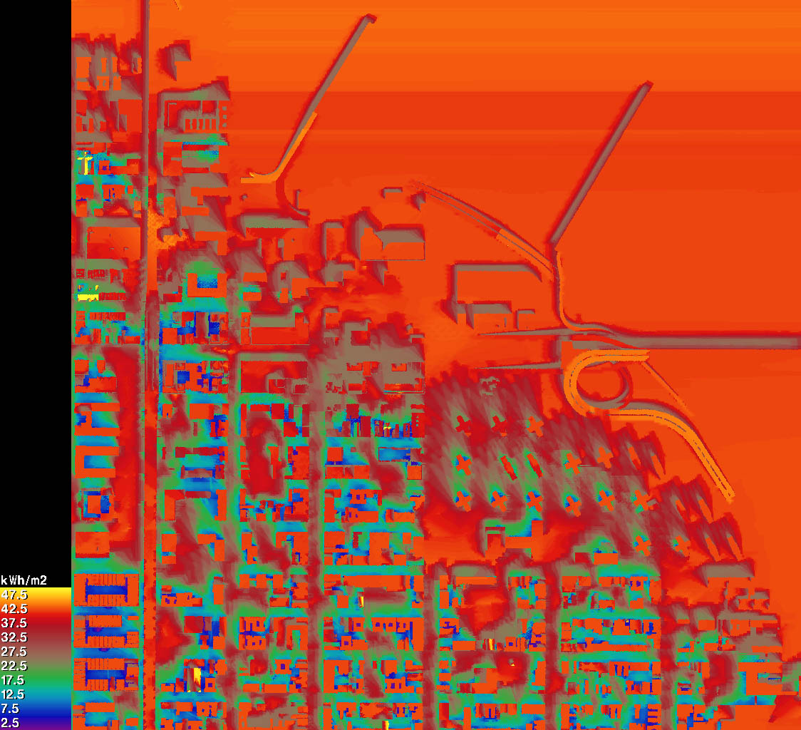
The rendering I am getting are not smooth and I am seeing horizontal
bands on these renderings. I am not sure what exactly the problem is. I
have tried to run simulation several times, in different computers, but
each time I get similar results.
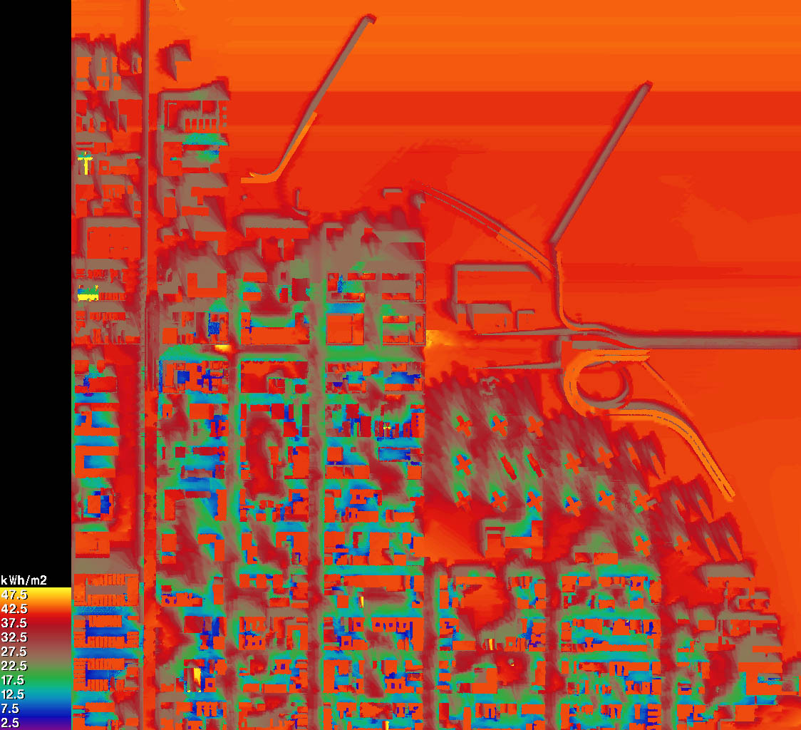
I am providing you all following links which has false color images of
existing and proposed conditions, and a file which has all rendering
commands and the background process that is carried out during
simulation, (hoping this would help).
Radmap falsecolor image links:
[root@localhost ~]# python /root/Desktop/radmap (background
process)
http://esc.freeshell.org/Radiance/exist_test_0000_irrmap_fc_kWh.jpg
(existing condition simulation)
http://esc.freeshell.org/Radiance/proposed_test_0000_irrmap_fc_kWh.jpg
(proposed condition simulation)
I would really appreciate if someone could help me figure out what's
going on with this simulation.
Thanks in advance,
Prasanta
···
-----Original Message-----
From: Francesco Anselmo [mailto:[email protected]]
Sent: Monday, December 03, 2007 5:02 PM
To: Radiance general discussion
Subject: RE: [Radiance-general] Radmap: to produce irradiation map
Dear Prasanta,
Sorry for the late reply, and thanks to Rob for helping out.
I assume, for latitude 40.8 north, longitude 73.9 west & meridian 75
west of Greenwich, the location options in radmap should be
"-a 40.8 -o -73.9 -m -75". Please correct me if I am wrong.
Yes this is correct.
Judging from your previous command line option you are using
the default cumulative sky method, and you can relax the sky resolution
to a lower value, for example 128, saving a lot of time without
compromising results.
As Rob pointed out, you should download a more recent version of
radmap, and on unix systems it runs without need to compile it,
provided that you have python installed.
Let me know how it works.
Ciao,
Francesco
Hi Prasanta,
You are using one month of hourly data, and in particular December.
Radiation his concentrated in the sun positions for each hour,
therefore it is normal to see strong shadows coming from
the suns. This sun displacement inaccuracy becomes less important
with bigger weather datasets, but for one month of hourly data it is
inevitable.
Ensure to use the -dt 0 option to account for all suns. It should
be on by default, and for the December month it should not do much
difference, but when evaluating annual cumulative irradiation
it becomes important.
Regards,
Francesco